
Tao-Klarjeti
Friday, August 6
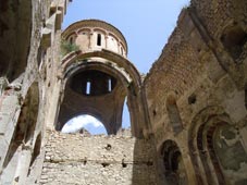
Historically, the area comprised the following provinces: West of the Arsiani Mountains were Tao, Klarjeti and Shavsheti, to the east lay Samtskhe, Erusheti, Javakheti, Artaani and Kola. The landscape is characterised by mountains and the river-systems of the Chorokhi and the Mtkvari. Tao-Klarjetis geographical position between the great Empires of the East and the West, and the fact that one branch of the Silk Road ran through its territory, meant that it was subject to a constant stream of diverging influences. In the 9th-11th centuries, Tao-Klarjeti was ruled by the Iberian Bagratids, and the region played a crucial role in the unification of the Georgian principalities into a single feudal state in 1008. Alongside the magnificent nature, the architectural monuments of Tao-Klarjeti (churches, monasteries, bridges and forteresses) today function as tourist attractions, but many monuments are at risk, as nothing is being done to preserve them. There have also been cases of deliberate destruction (for instance in Opiza and Tbeti).
In Armenian historical literature, the term Tayk is used for the Georgian Tao. The Tayk province covered contemporary Turkish districts of Yusufeli (Kiskim) in Artvin Province and Oltu, Olur (Tavusker), Tortum and Caml?kaya (Hunut) to the north of Ispir in Erzurum Province. To its southwest is found the ancient region of Sper. After World War I, Armenia and Georgia contested the region - in particular during the conflict over Oltu. As a result, Turkish rule was firmly re-established.
Klarjeti was a province of ancient and medieval Georgia, which is currently part of the Artvin Province in northeastern Turkey. Klarjeti, the neighboring province of Tao and several other smaller districts constituted a larger region with shared history and culture conventionally known as Tao-Klarjeti. Klarjeti, traversed by the Chorokhi (Coruh), stretched from the Arsiani Range westwards, towards the Black Sea, and was centred in the key fortified trading town of Artanuji. It was bordered by Shavsheti and Nigali to the north, and the Armenian-Georgian region of Tayk/Tao to the south. The region roughly corresponds to Cholarzene of classical sources and probably to Katarza or Quturza of the earlier Urartian records.
Shavsheti (Savsat) is a town and district of Artvin Province in the Black Sea region, between the cities of Artvin and Kars on the border with Georgia at the far eastern end of Turkey. Like most districts of Artvin this is a beautiful hilly area surrounded by high mountains on all sides, including the 3,537 m Karckal Mountains to the west, and watered by many mountain streams and pools. There are trout in the largest Savsat Karagol Lake and a number of mineral water springs. The area has a cold inland climate, somewhat tempered by being above the Black Sea coast, but at these altitudes winter lasts a long time; it snows from November to April. The mountains are covered with pine forest, with some broadleaf forest at lower elevations.
In this landscape there is little agricultural land, no industry and the only real potential income is from tourism (people on trekking holidays), herding animals on the mountainside and bee-keeping. There are some fruit trees (mainly pears and apples) and some potatoes are grown in the Chorokhi (Coruh) River valley floor. Of the land area 13% can be planted while 27% is used for grazing, 42% is forest and 17% is high mountain.